DJI D-RTK 3 Multifunctional Station
by DJIThe new D-RTK 3 Multifunctional Station integrates high-performance antennas and receiver modules capable of tracking and resolving data from major global satellite navigation systems, and it supports multiple data transmission links.
- Obročno plaćanje Obročno kartično plaćanje bez kamata 2-12 rata putem Visa Classic kartica u izdanju UniCredit Bank. Ostale načine plaćanje provjerite na linku: Načini plaćanja.
- Brza dostava Za sve narudžbe unutar BiH zaprimljene do 14h dostava će biti izvršena sljedećeg radnog dana. Više detalja provjerite na linku Načini dostave.
- Kontakt Mail: info@aviteh.ba - Telefon: 033 24 67 67 - Adresa poslovnice: Malta 29, Sarajevo
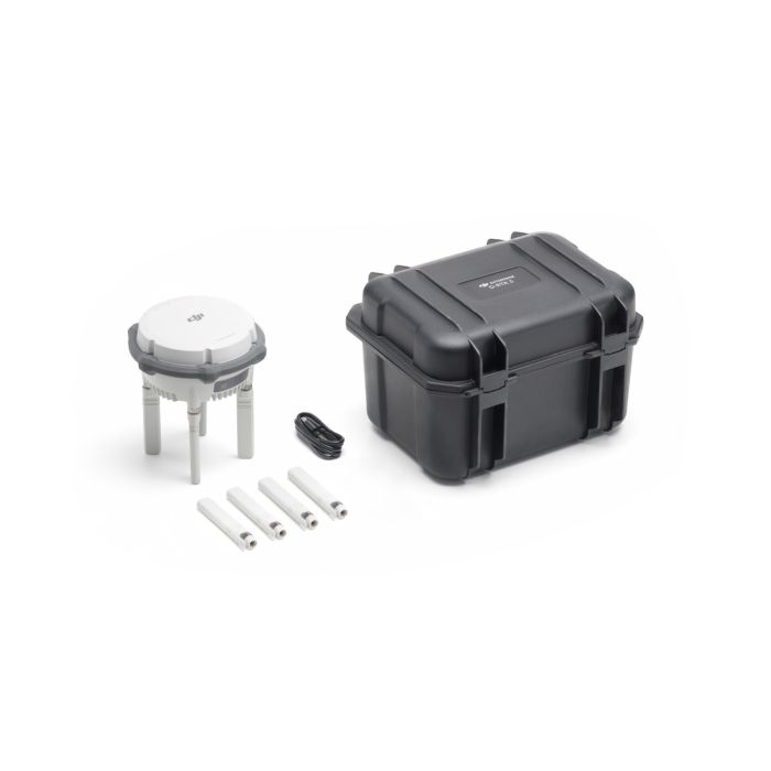
Sadržaj pakovanja
- D-RTK 3 Multifunctional Station × 1
- Spare OcuSync Directional Antennas × 4
- USB-A to USB-C Cable× 1
The new D-RTK 3 Multifunctional Station integrates high-performance antennas and receiver modules capable of tracking and resolving data from major global satellite navigation systems, and it supports multiple data transmission links. With these outstanding features, it can serve as a base station to provide centimeter-level positioning for multiple drones simultaneously or extend the operational range of drones and DJI Dock 3 in relay station mode. Additionally, the new rover station mode, combined with the DJI Enterprise app and DJI Terra, provides a comprehensive solution for high-precision aerial surveying applications, ensuring a secure and accurate operation.
Multiple Modes, Versatile Control
Relay Station Mode [2] : Break Through Limitations
In urban areas, valleys, or challenging DJI Dock 3 sites with dense obstacles, simply switch the D-RTK 3 to Relay Station Mode [2] and position it at a high point, or directly set up the D-RTK 3 Relay Fixed Deployment Version. This setup enhances the video transmission range for the Matrice 4/4D series, extending operational coverage up to 25 kilometers [3].
D-RTK 3 supports obstruction sensing with the Matrice 4 Series, allowing real-time calculations of obstructions and signal quality between the relay station, the remote controller, and drone. Operators can adjust the drone's position based on prompts from the remote controller to ensure optimal communication quality.
Base Station Mode: Supports Simultaneous Operation of Multiple Models
D-RTK 3 supports the new O4 Enterprise video transmission with four external directional antennas, enabling 15 km [1] video transmission in base station broadcast mode while ensuring stable signals in all directions. Operators only need to set up one D-RTK 3 Multifunctional Station without additional configuration, allowing multiple drones to connect to the base station and access centimeter-level positioning.
Rover Station Mode: Flexible and Efficient
Besides serving as a base station, D-RTK 3 can also be used as a rover station to collect control point coordinates, enhancing the accuracy of UAV aerial survey and improving survey precision.
Maintenance-Free Relay Fixed Deployment Version
Adaptable to Various Environments
The Fixed Deployment Version offers outdoor maintenance-free operation and adaptability to various environments. It can be installed on towers, utility poles, parapet walls, and other vertical structures, meeting diverse scenario requirements. Additionally, it supports power supply from DJI Dock 3 or third-party external PoE sources, enabling long-distance deployments.
Outstanding Protection and Reliability
D-RTK 3 Relay Fixed Deployment Version features highly redundant and reliable hardware and software design, significantly reducing maintenance costs. Equipped with lightning surge protection and an IP67 rating, it operates stably in temperatures ranging from -30°C to 50°C. Once deployed, it can continuously perform outdoor operations with minimal intervention.
Effortless High-Precision Positioning
Stronger Performance, More Accurate Positioning
D-RTK 3 uses an air dielectric antenna with a filtering design, effectively tracking low-elevation satellites. The antenna phase-center accuracy is maintained within millimeter level, ensuring strong resistance to multipath interference and enabling high-precision positioning even in complex environments.
With its built-in receiver module, D-RTK 3 can receive satellite data from five major satellite systems across nineteen frequency points. Compared to network RTK, D-RTK 3 provides more accurate and stable positioning results under ionospheric effects.
Standalone Precise Point Positioning (PPP)
D-RTK 3 utilizes DJI's proprietary PPP solution, enabling satellite-based auto convergence*. It provides free decimeter-level positioning even in challenging network conditions.
* Currently supports BeiDou PPP-B2b only.
Network High-Precision Calibration
D-RTK 3 can receive RTCM data and automatically obtain coordinates and correct positions through the network. When used outdoors, it can achieve centimeter-level precision positioning without pre-measuring the setup point location.
DJI Integrated Mapping Solution
New DJI Enterprise App
Supports Ground Control Point (GCP) Setup and Tilt Compensation
Install the new DJI Enterprise app on an Android device to measure ground control point coordinates without third-party tools. When used with DJI drones supporting RTK, the DJI solution can efficiently complete an entire high-precision surveying workflow.
D-RTK 3 has a built-in high-precision inertial measurement unit, allowing the control point to be measured when the pole is held at an angle without a tripod or ensuring the base station is vertical, significantly improving operational efficiency in complex measurement environments.
Supports Projection Coordinate Conversion
The new DJI Enterprise app includes a mainstream projection coordinate database, allowing direct output of planar coordinates.
Compatible with DJI Terra for Efficient Data Processing
One-Click Import, Time-Saving and Effortless
Rover measurement results can be exported as control point files via the DJI Enterprise app and imported into DJI Terra without the need for additional format adjustments. With powerful algorithms, high-precision results can be easily generated.
Supports Local PPK
D-RTK 3 supports recording raw satellite observations. When imported into DJI Terra version 4.4 or above along with data from the Matrice 4E, local PPK calculations can be performed with one click.
* Tested with a production model D-RTK 3 Multifunctional Station in a closed environment in favorable conditions with an unobstructed wireless signal. Actual results may vary depending on the environment, usage, and firmware version.
** All videos and photos on this page were shot in strict compliance with local laws and regulations. Demos were shot from a safe distance and are used for reference only. Please observe local laws and regulations and ensure the aircraft has obtained relevant certifications before flying.
1. Measured in an outdoor, open environment, without interference, and with FCC compliance. The above data shows the farthest communication range for one-way, non-return flights. Always pay attention to reminders in the app during your flight.
2. This feature is unavailable in countries or regions without 5GHz frequency support. Check local laws and regulations for more information.
3. Measured under FCC standards. The maximum video transmission distance under SRRC standards is 12 km, ensuring no obstructions between the relay station and the drone, and the distance between the relay station and the remote controller is less than 1 km.
4. The value-added services offered may vary by country/region. For details, please consult your local dealer.
5. Low-Cost Replacement: Enjoy the same performance and reliability as new products; Official Warranty: Refer to the "After-Sales Service Policies" section in the "Support" pages on DJI's official website for details; Free Shipping: Available in regions covered by DJI Care Enterprise. Users are responsible for additional costs including logistics and customs duties incurred beyond the scope of coverage.
6. Unlimited Number of Free Repairs: Get free repairs within the coverage scope and amount; Coverage for Your Whole Fleet: Shared coverage can be extended to other DJI Enterprise devices bound to DJI Care Enterprise Plus within the same time period (30 calendar days) after the first activation and binding; Free Shipping: Available in regions covered by DJI Care Enterprise. Users are responsible for additional costs including logistics and customs duties incurred beyond the scope of coverage.
| GNSS Receiver | GNSS Frequency |
| GPS: L1C/A, L2C, L5 | |
| BDS: B1I, B2I, B3I, B1C, B2a, B2b | |
| GALILEO: E1, E5a, E5b, E6 | |
| GLONASS: L1, L2 | |
| QZSS: L1C/A, L2C, L5 | |
| L-Band | |
| System Accuracy* | Base Station Mode (Broadcast Mode) and Relay Station Mode |
| Base Station Accuracy: | |
| Single Point Accuracy (Uncalibrated): | |
| Horizontal: 1.5 m (RMS) | |
| Vertical: 3.0 m (RMS) | |
| Satellite-Based Differential Accuracy: | |
| Convergence Time: 20 mins | |
| Horizontal: 30 cm (RMS) | |
| Vertical: 40 cm (RMS) | |
| Network RTK Calibration**: | |
| Horizontal: 1.0 cm (RMS) + 1 ppm | |
| Vertical: 3.0 cm (RMS) + 1 ppm | |
| Rover Station Mode* | |
| RTK Accuracy (Fixed Survey): | |
| Horizontal: 0.8 cm (RMS) + 1 ppm | |
| Vertical: 1.5 cm (RMS) + 1 ppm | |
| RTK Accuracy (Tilt Survey)***: | |
| Angle Range: 0° to 60° | |
| Horizontal: 8 mm + 0.7 mm/° tilt (accuracy <2 cm within 30°) | |
| * Measurement accuracy depends on various factors. This value is obtained under normal conditions with an unobstructed view, good satellite distribution, low ionospheric activity, and no electromagnetic interference or multipath effects. | |
| ** Base station calibration coordinate accuracy depends on various factors. For surveying, high-precision flight paths, etc., it is recommended to calibrate during periods of inactive ionosphere, in open, unobstructed environments with no electromagnetic interference or multipath effects, using four or more GNSS systems. | |
| *** Intense vibrations and rapid rotations can affect the accuracy of the inertial measurement unit. | |
| Satellite-Based Precise Point Positioning* | Supported Frequencies: BDS B2b, GALILEO E6**, L-BAND** |
| Convergence Time: 20 mins | |
| Horizontal: 30 cm (RMS) | |
| Vertical: 40 cm (RMS) | |
| * Measurement accuracy depends on various factors. This value is obtained under normal conditions with an unobstructed view, good satellite distribution, low ionospheric activity, and no electromagnetic interference or multipath effects. | |
| ** Will be supported in later versions. | |
| Differential Data Transmission Format | In rover station mode or in calibration mode for base and relay stations: |
| When used as a base station or relay station, records RTCM 3.2 raw observation data in DAT format. | 1. Supports RTCM v3.0, v3.1, v3.2, v3.3, MSM4, MSM5, MSM6, MSM7 protocols. |
| 2. It is recommended to use receivers that support four or more GNSS systems. | |
| Initialization Reliability | >99.9% |
| Video Transmission | |
| Video Transmission System | O4 Enterprise |
| Operating Frequency | Relay Station Mode: |
| O4: 2.4 GHz/5.2 GHz/5.8 GHz | |
| Base Station Mode: | |
| O4: 2.4 GHz/5.8 GHz | |
| Rover Station Mode: | |
| BLE: 2.4 GHz | |
| Operating frequency allowed varies among countries and regions. Please refer to local laws and regulations for more information. | |
| Transmitter Power (EIRP) | 2.4000 GHz to 2.4835 GHz: |
| <33 dBm (FCC) | |
| <20 dBm (CE/SRRC/MIC) | |
| 5.150 GHz to 5.250 GHz: | |
| <23 dBm (CE/FCC) | |
| 5.725 GHz to 5.850 GHz: | |
| <33 dBm (FCC) | |
| <30 dBm (SRRC) | |
| <14 dBm (CE) | |
| Bluetooth | Protocol: Bluetooth 5.1 |
| Frequency: 2.400 GHz to 2.4835 GHz | |
| Transmitter Power (EIRP): <10 dBm | |
| Max Transmission Distance (unobstructed, free of interference) | Base Station Mode |
| Between D-RTK 3 and the aircraft: | |
| FCC: 15 km | |
| SRRC: 12 km | |
| CE/JP: 8 km | |
| Rover Station Mode: | |
| Between D-RTK 3 and mobile devices: 30 m | |
| Measured in an unobstructed outdoor environment free of interference. The above data shows the farthest communication range for one-way, non-return flights under each standard. Always pay attention to RTH reminders in the app during your flight. | |
| Max Transmission Distance in Relay Station Mode (unobstructed, free of interference) | FCC |
| Between the aircraft and the relay station: 25 km | |
| Between the relay station and the remote controller/DJI Dock 3: 1 km | |
| SRRC | |
| Between the aircraft and the relay station: 12 km | |
| Between the relay station and the remote controller/DJI Dock 3: 1 km | |
| CE | |
| Between the aircraft and the relay station: 10 km | |
| Between the relay station and the remote controller/DJI Dock 3: 300 m | |
| Measured in an unobstructed outdoor environment free of interference. The above data shows the farthest communication range for one-way, non-return flights under each standard. Always pay attention to RTH reminders in the app during your flight. The relay station should be placed in a elevated, unobstructed location to ensure clear communication between the remote controller and the aircraft. | |
| Max Transmission Distance (unobstructed, with interference) | Strong interference: City centers, approx. 1.5-5 km |
| Medium interference: Suburban areas, approx. 5-15 km | |
| Micro interference: Remote areas/seasides, approx. 15-25 km | |
| Data is tested under FCC standards in unobstructed environments of typical interference. Only to serve as a reference and provides no guarantee as to the actual flight distance. | |
| Max Transmission Distance (obstructed, with interference) | Low Interference and Obstructed by Buildings: approx. 0-0.5 km |
| Low Interference and Obstructed by Trees: approx. 0.5-3 km | |
| Data is tested under FCC standards in unobstructed environments of typical interference. Only to serve as a reference and provides no guarantee as to the actual flight distance. | |
| Relay Station Range Extension Effect | Relay Station Performance Enhancement: |
| Severe obstruction (e.g., buildings, mountains): 3x to 5x performance improvement | |
| Mild obstruction (e.g., trees, glass): 1x to 3x performance improvement | |
| The relay station must be deployed in an elevated, unobstructed location free of interference. | |
| Antenna | OcuSync 4 directional antennas× 4, 2T4R |
| The antenna uses a standard reverse polarity SMA connector. | |
| Others | D-RTK 3 Relay Fixed Deployment Version: Compatible with DJI Cellular Dongle 2 |
| Electrical Properties | |
| Power | D-RTK 3 Multifunctional Station: |
| Relay Station: 14.5 W* | |
| Base Station: 7 W | |
| Rover Station: 6.2 W | |
| * Maximum power consumption without heating. When connected to a USB-C power supply above 9V, maximum power consumption with heating is 36.5 W. | |
| D-RTK 3 Relay Fixed Deployment Version: | |
| Relay Station: 14.5 W** | |
| ** Max power consumption without heating. When connected to a PoE power supply of Type 4, maximum power consumption with heating is 36.5 W. | |
| Power Output Port | D-RTK 3 Multifunctional Station: USB Type-C |
| D-RTK 3 Relay Fixed Deployment Version: USB Type-C and Ethernet Port (PoE) | |
| Supported Power Adapter | D-RTK 3 Multifunctional Station: |
| USB PD 3.0 protocol, output voltage 9V to 15V adapter (e.g., DJI 65W Portable Charger) | |
| When using a non-recommended charger, such as a charger with 5V-output, the D-RTK 3 can be charged only after powering off. | |
| D-RTK 3 Relay Fixed Deployment Version: | |
| DJI Dock 3 PoE Output Port | |
| Third-party PoE Power Supplies: | |
| IEEE 802.3bt Type 4 (PoE++): 52 V to 57 V output, 99.9 W max | |
| IEEE 802.3bt Type 3 (PoE++): 50 V to 57 V output, 60 W max | |
| IEEE 802.3at Type 2 (PoE+): 50 V to 57 V output, 30 W max | |
| Battery Operating Time (Under Normal Temperature)* | D-RTK 3 Multifunctional Station: |
| Relay Station: 4 hrs | |
| Base Station:7 hrs | |
| Rover Station: 10 hrs | |
| D-RTK 3 Relay Fixed Deployment Version: | |
| Relay Station:4 hrs** | |
| * Battery performance may decrease in low temperatures; it is recommended to use power adapters that support the USB PD 3.0 protocol. | |
| ** When powered by PoE, the device battery enters preservation mode and does not fully charge. Upon PoE disconnection, the built-in battery delivers up to 2 hours of runtime. | |
| Ethernet Cable Requirements | D-RTK 3 Multifunctional Station: |
| Ethernet not supported | |
| D-RTK 3 Relay Fixed Deployment Version: | |
| Requires Cat 6 twisted-pair cable, ≤100m length, 6-9mm outer diameter. | |
| Battery | LiPo |
| Capacity: 6500 mAh | |
| Energy: 46.8 Wh | |
| Physical Characteristics | |
| Operating Temperature | D-RTK 3 Multifunctional Station: -20° to 55° C (-4° to 131° F) |
| D-RTK 3 Relay Fixed Deployment Version: -30℃ to 55° C (-22° to 131° F) | |
| 1. In normal temperature environments, charging power will be limited if the device shell temperature exceeds 48°C (118.4°F). Full power charging will resume after cooling. | |
| 2. After storage/use in low temperatures, the device needs to be brought to a normal temperature environment and allowed to warm up until the internal battery temperature is >0°C (32°F) before charging. | |
| 3. After storage/use in high temperatures, the device needs to be brought to a normal temperature environment and allowed to cool down until the internal battery temperature is <45°C (113°F) before charging. | |
| 4. When connected to Type 4 PoE power, the D-RTK 3 Relay Fixed Deployment Version enables heating for low-temperature startup. | |
| Altitude | 6000 m |
| Protection Rating | D-RTK 3 Multifunctional Station: IP67* |
| D-RTK 3 Relay Fixed Deployment Version: IP67** | |
| * Please ensure all rubber seals are securely installed for optimal performance. | |
| ** The rubber seal on the PoE input port of the Fixed Deployment Version provides IPX5-rated protection. IP67 protection requires installation of the dedicated PoE port connector and cable. | |
| Drop Resistance | D-RTK 3 Multifunctional Station: 2 m drop with pole |
| Dimensions | D-RTK 3 Multifunctional Station: 163 mm × 89 mm (without OcuSync Directional Antennas) |
| D-RTK 3 Relay Fixed Deployment Version: 163 mm × 344 mm | |
| Weight | D-RTK 3 Multifunctional Station: Approx. 1.26 kg (2.78 lbs) |
| D-RTK 3 Relay Fixed Deployment Version: Approx. 2.24 kg (4.94 lbs) |
- -16%Novo
 Zhiyun Molus X200RGB COB Light ComboNormalna cijena 1.459,00 KM Posebna cijena 1.225,50 KM 1.047,44 KM
 - -16%Novo
 Zhiyun Molus X200RGB COB Light StandardNormalna cijena 1.219,50 KM Posebna cijena 1.024,25 KM 875,43 KM
 - -16%Novo
 Zhiyun Molus X200 COB Light ComboNormalna cijena 1.339,50 KM Posebna cijena 1.125,00 KM 961,54 KM
 - -17%Novo
 Zhiyun Molus X200 COB Light StandardNormalna cijena 980,00 KM Posebna cijena 813,25 KM 695,09 KM
 - Novo

- Novo